Snowshoe work meeting? Heck yeah

Yesterday I had a work meeting while snowshoeing up past Big Springs.
It was the best work meeting I have ever been too.
Nebo - my nemesis
Yep, got stormed off Nebo again...


My friend Bronc, his 12 year old boy Caleb, and myself spent the night on Nebo (just below the bowl) with the plan to hit the summit the next morning. It rained all night and still was when we woke up. A fast packer headed up the mountain and quickly returned, reporting that the storm and lightning was really bad up on top.
We waited for sometime and then decided to head down and try another day. On the way down we ran into a couple groups that were going for it anyways.
Turns out they made a smart decision because when we got back the truck the sky was overcast, but the summit was clear.
We still had a good time, and a nice night swinging in our hammocks.
Oh, and we stumbled up a dead cow that a bear had been feeding on. I'll save you all the details of why we think it was a bear's dinner, but we are pretty convinced.
If I get the opportunity I am going to hit the top of this place before it snows.


Bronc, loving the smell of the bear cache
Red Castle - 3 day trip
This post could be a lot longer than it is.


And this is the zoomed in view of just around the castle


And through meadows


...slaughtered some fish,...

...and looked off the edge of the world.


And ate our take home (the guys probably through at least this many back)


Red Castle is a geological formation sticking out of the ground at the headwaters of Smiths Fork River. It is located just south of the Wyoming-Utah border in the High Uinta Wilderness. Our plan was to spend 3 days backpacking the castle.
On this trip:
Jared Moore, Spencer Walker, Bronc Walker, Me, Chris Parks, Devon Parks
(just a group of good fellas, that's all)
Jared Moore, Spencer Walker, Bronc Walker, Me, Chris Parks, Devon Parks
(just a group of good fellas, that's all)
The trail begins at China Meadows trial head and you approach the castle from the north. I had learned about this place from my friend Cordell Andersen and decided that I needed to go there.
We camped the night of the 12th in the China Meadows campground. The next morning, after a really good breakfast and after everyone finally got themselves together, we headed down the trail.
The trail cuts back and for across the river, staying mostly in the woods, until you reach the castle about 11 miles later.
Parts of the trail have improvements, like this boardwalk that stretched for a few hundred yards. and 3 foot bridges where you cross the river
This is the GPS route for the total trip, 46 is our camp.
And this is the zoomed in view of just around the castle
I don't have many pictures from the trek into the castle because it rained for 6 hours strait.
We did meat some interesting people along the way, including a husband and wife on a goat packing trip. They had been out for about 2 weeks. The goats carry about 40 lbs a piece and live off the land.
We walked all the way to the Lower Red Castle lake and then hung east around to East Red Castle lake where we had planned to camp. However, the storm was to rough up there and we were forced to retreat, and make camp in a small cove, with plenty of trees for our hammocks.
As we all lay in our hammocks and tarps, listening to the rain and wind, we worried that the trip would get wasted by the weather. I don't mind camping in the rain. It is kind of nice sometimes. But in this case we had at least 3 lakes we wanted to fish, an entire castle to explorer, and a possible summit of Wilson peak.
But the prayers must have paid off, because we woke to perfect weather that would last until dinner time.
We Traveled back up to East Red Castle lake for some fishing. This is one of the most beautiful place I have ever seen. And we had it all to ourselves.
We then traveled around the north end of the castle.
Across boulder fields
And through meadows
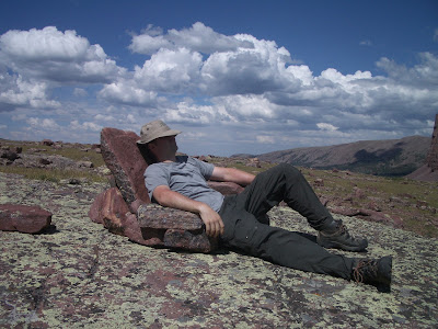
And up to Red Castle Lake. Were we sat in a natural lazy-boy, and...
We enjoyed a quick rain on the way back to camp...
And ate our take home (the guys probably through at least this many back)
I enjoyed the scrumptious taste of the first fish that I've caught in Utah, a little Tiger trout.
But that night the weather turned again and we woke up to a pending storm, and high tailed it out of there.
After having walked about 32 miles in rain, perfect sun, hail, and even snow, we arrived at the truck in pretty good condition.
It was a great trip, one that I would highly recommend.
a couple of miles are missing off this elevation chart due to loss of gps reception in the storms
Maple Canyon - Right fork
This morning I went back up the Right Fork of Maple Canyon. Today however was not a solo hike, in fact it turned out to be quite different from a solo hike.
TJ Wurth and I started the trip the same as any other trip. We cruised along at a good pace. Along the way we caught up to a large youth group. Which turned out to be a very small portion of a much larger youth group. They had 4 teams on the trail. An Advanced team, looking to clear the saddle just below the summit. A forward team, looking to make it to the lake. A moderate team, just out for fun. And a back team of people they knew would poop out early.
We passed the moderate team and kept going. The trail was incredible. All of the rain lately has everything green like Eden, and the wildflowers are out in large numbers.


About a mile down from the lake we spotted the forward team from the youth group. We caught up to them shortly and stopped to talk. Suddenly one of their young women fainted. We got her laying down in the proper position and made sure she was ok.
TJ and I headed up the trail to find their advanced team at the lake and let them know that they might need to help. Turns out they had horses up on top and so the rescue suddenly became a lot easier. Which I was very relieved about, since this trail is hard enough to get yourself down, much less someone else too.

We decided not to summit because we were now behind schedule, there was still a lot of snow up there, and mother nature was getting ready to show us who was boss.....again.
The rain ended up coming down hard enough to be running down the hillside. Making this steep rock-covered trail even more difficult to navigate.

Back down from the lake a few hundred yards we caught a glimpse of something moving in the dense foliage of the east slope. We soon realized that it was 2 day-hikers and intercepted them on the trail. The poor fellows had been given bad directions and had ended up going up Dibbles Canyon when they had meant to go up the right fork of Maple. They weren't really lost, they new essentially where they were and how to get back down, but they had been through a hard bushwhack to get from Dibbles to RF of Maple. Not something that I will be putting on my to-do list. But we had a nice hike down together.
We finally made it down, after all the drama, about 5 and a half hours after leaving. Just goes to show: be ready for the unexpected. A 3 hour trip can become 5. People can be falling down around you, you never know who or what might pop out of the woods, and mother nature can kick your trash anytime she wants.
the default setting for videos is low quality, you can click "View HQ video" for better res
Stats:
3,436 verticle gain
Ricky, Slick, and wet
Dibbles Canyon
Today was perfect for a trip to the mountains. I decided to do a solo hike up Maple canyon, then splitting off into Dibbles canyon, and hopefully making it to the saddle that drops into diamond fork.
It turned out to be the best trip yet this summer. I couldn't have asked for much more.
I actually met my pal TJ Wurth coming down the trail, he had already been out for about 2 hours and we caught each other at the trail head. He turned right around and followed me up the trail for a little over a mile, it was nice to have company for part of the trip. And then after that, I didn't see or hear another soul until i returned to the main trail.
Dibbles canyon trail starts out in a pine forest and follows a seasonal creek through the pines and into the aspens.
 The wild flowers are very healthy and colorful right now. I counted at least 8 different species.
 The trail opens up into a couple of incredibly beautiful meadows. I am definitely going to have to spend the night sometime.
The view as you begin to approach the saddle. The crest of the saddle sits at 7,671 feet. The peak to the left of the saddle is un-named.
 Hmmm. Interesting markings about 7 feet up on this tree.
If I would have had more time, I would have stretched out under this tree....

....and fallen asleep to this view.


I can't prove it. But I am pretty certain that the path leading up to the gates of Heaven, is lined with an Aspen grove.

Dibbles Canyon Walk through
Stats:
Trail head: Whiting Campground - note: they are now charging a $6 day pass
Starting elevation: 5,571
Saddle crest elevation: 7,671
Total vertical gain: 2,094
Round trip miles: 6.5
Average grade: 12%
Dibble Canyon Partial Profile - GPS reception is very sketchy for the lower half of the trip

The Hammock
Last year I started camping with a hammock. I couldn't ever seem to get comfortable in a tent. Yeah there was a lot of space in my 2 man, but the ground and I never got along very well. Plus I was tired of carrying a 6 lb tent around.


So I purchased a simple Travel Hammock for $20.
This hammock converted me to the way of the hammock. Weighing just over a pound and packing down to the size of Nerf football was a huge benefit to my new lightweight backing life.
But the comfort is what really got me. For me a hammock works great. The banana shape doesn't bother me very much, and it's way better then the bumps and slants of the ground.
Then towards the end of last summer, a mistake on my part caused a rip in this hammock.
So for my graduation present my parents got me a Clark Ultra Light Jungle Hammock. Which I used for the first time last night.
This hammock is very comfortable. It has great balance that allows you to turn and lay on your side easily. It also has a built in mosquito net and rain fly (both removable). I didn't use the mosquito net last night, but man did I get my money's worth out of the rain fly. It rained for 8 hours straight, and not a single drop got into the hammock. And this wasn't some wimpy rain, it was a monsoon by Utah standards.
This hammock isn't cheap, but if you like hammock camping, it's worth the money. It packs down small and weighs a little over 2 pounds.
Can't wait to use it some more!
Maple Canyon Left Fork - Spring Starter trip
Today I went on my first day hike this spring. I really love this time of year. The weather is perfect for hiking, just cool enough to keep you from getting hot when moving, but not enough to chill you when you stop. We also had great cloud cover today, which I also appreciate.
The wild flowers have started blooming.....
 ....and in large numbers.
The runoff has been going on for a good 2 weeks and it still has some pretty good volume behind it. The left fork of Maple Canyon follows the creek consistently and provides for some pretty great finds.
 This tree was amazing. It's branches had grown out to the trail where it could get the sunlight, and then straight up.
  Maple Canyon is a great day hike. There are many different types of trees and the woods around the trail and creek have some real character. This trail also goes all the way over the mountain making for a great one night through-hike that I hope to do this summer.
  Thanks to Lars (seen here) and TJ for coming along. I had a great time.
Stats: Turns out to be almost exactly 3 miles round trip, but the GPS has a hard time keeping a signal in the canyon - as you can see below.
3 miles
966 feet of vertical climb

Subscribe to:
Comments (Atom)
