Mount Nebo

I was invited by my ol' pal Bronc Walker to join in an over-nighter to the top of Mount Nebo. Mount Nebo is the highest peak in Utah County, and for some reason was not on my "To Do" list, so passing up the chance was not an option.
Bronc, his son Caleb, and I left late on Friday night, hiked in the dark and made camp a little under 2 miles from the trailhead. The woods, just below the timberline, were perfectly quiet; and the stars were in their shiniest array. We were shortly joined by Bronc's brother Spencer, their sister Amy, and Clyve and Paul - some friends of Spencer's who have recently moved from England. We kept eachother entertained with everything from hospital horror stories, to companaring slang terms in the English and American languages.
That night's camp was of perfect wilderness comfort, and as a red sun rose through the trees, we made for the summit.

Other peaks rise from the trail, and to the north the populated valley, though gorgeous, reminds one of why we need these wilderness areas.


To the south-east several valleys and mountains take turns claiming their place on earth.

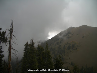
But that view also revealed an incoming storm.

The summit still looked promising........

....then the weather changed.
....then the weather changed.

We continued climbing along one of the best, most stunning trails I have ever been on. Every turn and ridge brought more glorious views then the last.

 We waited out the first bit of rain and hail in a stand of trees. And then continued up the towards the summit. With only 200 vertical feet to the summit of the north-minor peak, and 1,000 vertical feet to the main summit, the weather suddenly changed.
While the group debated about weather to continue or not, a cloud rolled in from the east at an astonishing pace.

This cloud moving in, the consistent stream of day-tippers coming off the peak at a scurrying pace, and the words of one of them upon hearing our debate - "The summit will always be around, you may not be" - was enough to convince me to take the safer road, and save the summit for another day.
Bronc, Caleb, and I enjoyed a nice descent back to camp and on to the trail head. Spencer, Clyve, and Paul pushed for the summit. Clyve had a different theory - "I am 48 years old, I may not be around either way" - and they were willing to risk the weather.

In the end everything turned out terrific. We all enjoyed an uplifting trip, half of the group made it to the north summit, and I am left with an exciting addition to my "To Do" list - Finish off Nebo.


See more pictures and an altitude chart here
Mel Loves to Hike
Mel loves to hike, and so this morning we went on about our 4th hike of the summer. We went above Springville to the trail that follows Spring Creek up the mountain.
It was a simple little trip with Mel leading us up and down various trails, exploring as we went. The sunrise was beautiful and the morning air perfect.


Mel even took a few pictures:

Shoreline Trail
The Uinta National Forest backs right up to Springville, where the roads meet the Wasatch Mountains. All along this border between city and forest is the Shoreline Trail.
The shoreline trail is a lightly used trail that accommodates hikers, mountain bikers, and some atv's. But the great part about the Shoreline is that almost every canyon there is a trail running off into the wild and none of these are usable by anyone except those on their feet.

I took a sunrise trip along the trail this morning. It was a perfectly calm morning and made for some great views of the valley and surrounding mountains. I always wonder what this place must have been like when the Trappers like Bridger and Provost would wander through here. But the valley is still very beautiful, even with civilization having taken over.
This is a shot across Springville to West Mountain, that sits at the south end of Utah Lake.

Looking south over Springville and Mapleton you can see Spanish Fork peak, the tall one on the left, just below that peak is Maple Lake that I
wrote about a couple posts ago.
South and West of Spanish Fork peak the morning sun lights Mt Nebo's peak.

Nebo is the highest peak in Utah County, yes it is Higher then the famed Timpanogos. At 11, 928 feet, Nebo's summit will be the object of a trip I will be going on later this month. Hopefully the weather will hold out.
The Shoreline trail is a great example that you can have a little adventure every day, and that a simple morning hike before work goes a long way to improving your whole day.
An "expedition" 3 years in the making
Ok, so my pal Seth Chase and I have been talking about going camping together for 3 years now. We finally picked a day to go not matter what. That day was last night. Circumstances suggested that the best course of action would be to go car camping! I had to smile at myself because I have been working so hard on doing more backpacking, but I really enjoyed this out-of-the-jeep campout.
Even packing for the event was easier, I just stuffed everything I could possibly want into my multi day pack and tossed it in the Jeep. That was much easier than the usual, methodical, almost OCD type of packing I usually do.
We took the right fork of the Hobble creek up and over into an Aspen grove in Ray's valley.
 There were still some wild flowers in the area, a breeze carefully quaked the aspens, and the stars were out in their full glory.

 Mostly Seth, his father Bob, and I just jawed-on around the fire and relaxed.
Sometimes we spend so much time planning and preparing and then trying to make the most of an adventure, that we end up ruining it. This camp out was a terrific reminder that keeping things simple can make expeditions so much more enjoyable.
All we planned for this trip was what we would eat, and the very general area of were we would be, and it all worked out terrifically.

Maple Lake Ala Impromptu
 On August 16th I "up and decided" to go on an evening hike.I was planning on just going about 2 miles up the right fork of Maple canyon, but for some reason the mountain got inside of me and I just kept going.
The trail is steep and had ankle-breakers along its entire length. My trekking poles made a huge difference on this trip. Since I had planned to stay on the graded road and not get on the actual trail I had only worn my sports sandals, and not my boots. This greatly added to the difficulty of the trail - big mistake.
Yet I ended up hiking the almost 4 miles into Maple Lake, which during this time of year is actually more like Maple Pond.
I met several bow hunters along the trail. Some of them, fully equiped with riding and pack critters, were rather wide eyed when they saw me standing by the lake in my sandals, shorts, and small daypack.

All along the way there were different types of wild flowers. I have yet to identify any of them, but they were quite beautiful.
The trail starts as a broad graded road, and then turns into a steep, rocky, yet well worn single track. Some of the trail is so overgrown on each side that you stop just short of simply having to bushwhack your way through.
 From Maple lake you can see Spanish Fork Peak, and this evening I was favored with a beautiful sunset.
The decent is not an easy task. Rocks threaten to twist your ankle with every step (especially in sandals), my trekking poles saved my rear end more then once on the decent. Sadly, one of the poles did not make it out unharmed. It now hangs in my garage, a mangled version of its former self; though this is a sad event, I am certainly happy that my tail bone is not suffering the same mangleing.
I plan on going back to Maple Lake and finishing the trail to the top of Spanish Fork Peak, and enjoying "Utah County's hidden little secret" some more.


The Flaming Green
During the first week of August I spent one night in the Uintas and then 3 days on the Green River as it flows from the Flaming Gorge Dam. This was the second time that I made this trip and it was just as amazing as the first time I went.

 As the river continues, one can enjoy the comfort of well built and maintained camps, historical sites, and even a pay-phone, but the wild creeps in more and more as the miles continue.

The flaming cliffs of the Red Canyon tear into the blue ski above the first dozen miles of the river. The river winds along the path that it has so painstakingly carved from the red rock over the last several thousand years. The river controls its tremendous power with gentle care, demanding your respect with every bend.
Trout, that would leave leftovers, swim past the boat with clearly displaying their confidence in avoiding the Petty traps of man.
 As the river continues, one can enjoy the comfort of well built and maintained camps, historical sites, and even a pay-phone, but the wild creeps in more and more as the miles continue.
The Red Canyon gives way to grass covered banks and views of the surrounding mountains, as Swallow Canyon slowly creeps up.
 This is an adventure that deserves all of praise that a simple writer can give.
The 32 river miles from the dam to the Swinging bridge, just inside the Colorado border, give the floater a variety of water and land experiences.
 This is an adventure that deserves all of praise that a simple writer can give.
Subscribe to:
Posts (Atom)
